Sunday, April 12, 2009

Bandera Volcano: Ever So Peaceful A Place


An invisible creature dislodged a small lava rock high above me. First, I heard the rock hit other rocks making ever so slight of a sound that it might have gone unnoticed. I watched the small rock roll then come to rest on a slope where now it may set for an eternity. How very minimal this change to the landscape compared to what happened on this site some 10,000 years ago.

The Bandera Volcano violently erupted back then sending a flow of lava nearly 23 miles long. Imagine the sound of the blast that created the Bandera Carter measuring nearly 1,400 feet wide at the top and roughly 800 feet deep. Imagine the sight of the orange-red molten lava flying into the air then crashing down this main vent and all around. What a thunderous noise must have echoed through these New Mexico mountains when the high pressure lava began to fly and the molten rock that hardened in midair crashed back to the ground. It’s quiet at the Bandera Volcano now, ever so peaceful like a tantrum child whose made a racket and settledfor a quiet nap, for the Volcano a long nap.

Generations of the Candelaria Family have preserved the Bandera Volcano and another natural wonder - the Ice Cave. (See “When You Can’t Get to Carlsbad, Go to the Ice Cave” http://glotours.blogspot.com/2009/04/when-you-cant-go-to-carslbad-caverns-go.html ). The connection of family members dates back to the early 1900s. I met Janet Candelaria O’Connorwho has lived in the shadow of the Bandera Volcano since 1946. Janet showed me a photo of her as a red-haired teenager on a 1956 tourist brochure. It appeared in a book her father David wrote called The History of The Ice Cave. She posed for a new photo taken by me standing next to the gallery of family photos in the Old Time Trading Post.

As a tourist attraction, Janet and her family pride themselves for keeping the Bandera Volcano and Ice Cave “natural” – what Janet said “people are looking for” when they visit. She told me that over the years she has noticed that walking the trail to the Bandera Volcano can “heal the spirit and soul.” She offered the example of stressed families. Parents might be yelling at their kids before the hike to the volcano. When they return, they appear peaceful possessing a more positive attitude. Had Janet made these comments before I made my trek up Volcano Trail, I might not have believed her, but I too felt the effect of this beautiful place.


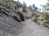
Nine observation points at numbered trail makers are explained in a self guided brochure which provides interesting details for folks making the hike up Volcano Trail. The first stop calls attention to the Lightening Tree, struck in July of 1992. Trees such as this one that grows in the old lava flow are prone to lightening strikes because of the high content of iron which attract the strike. Another stop highlights a Spatter Cone – a formation made by hot air rushing through lava and creating a type of blow hole. At one point on the trail called Volcano Land, visitors can look off into the horizon and see as many as 15 of the 29 other volcanoes in the El Malpais region. If that’s not enough to impress visitors, Devil’s Playground should. This large canyon marks the beginning of the Bandera lava tub. The lava spans out sharp and jagged as a solidified black mass across the terrain.


The best view came last. The Bandera Crater is a perfectly formed cinder cone said to be the USA’s best example of a cinder cone eruption. The massiveness dwarfed the pine trees growing from the cinders hundreds of feet below the trail lookout. The jagged lava walls of the cone looked deceivingly like rusty- brown velvet from this distance. No sounds other than a gentle wind and that one falling lava rock broke the peacefulness of this beautiful place. The Bandera Volcano emitted it own spirituality now at rest to be enjoyed by people like me who hike to see to this beautiful phenomenon.

April 6, 2009

Ice Cave Trading Co.

12000 Ice Cave Road

Grants, New Mexico 87020

1-888-ICE-CAVE

www.icecaves.com

From I-40, take Exit 81 in Grants, New Mexico.

Follow Route 53 and the signs to a left turn for

Bandera Volcano on Ice Cave Road.


Saturday, April 11, 2009

When You Can't Go to Carslbad Caverns, Go to the Ice Cave

“Go to the Carlsbad Caverns,” my friends on Facebook suggested when I wrote: “We’re in New Mexico. Any suggestions of places to visit?” As expected, Carlsbad ranked #1 as the destination of choice. I tended to agree with my friends. I am drawn to caves and actually traveled to the spectacular Carlsbad Caverns in 2005, two years before we began our 10,000 Mile Grand Tour of the US and Canada. On this current trip, Carlsbad was off course. Our travel route placed us on I – 40 in northwest New Mexico, Carlsbad Caverns is located in the extreme southeast corner – not an easy commute.

So as I apologize to my Facebook friends, I confess I listened to a young desk clerk at America’s Best Value Inn in Gallup, New Mexico. I’d wandered into the hotel on a Sunday night looking for a newspaper and some local information. I scored a discarded Wall Street Journal and found a rack of tourism brochures.

“What do you think of this place?” I asked the fellow as I held up the Ice Cave advertisement at his eye level to get attention.

“Oh, yeah. You should go there. I’ve heard it’s very nice from many of our guests.”

I took this desk clerk’s advice, the advice of a stranger, the advice of a local boy who had never been to the venue in his own backyard over my trusted advisers, my friends. He gave me good advice.

From I-40, take Exit 81 in Grants, New Mexico. The Ice Cave is on Route 53 – the “Trail of the Ancients,” a New Mexico Scenic Byway. Route 53 is the traditional path between Pueblos of Acoma and Zuni. It is the route taken by Coronado on his famous exploration. It’s a route I’ve added to our Grand Tour Map on our Prevost wall. Destination signs clearly mark the dusty turn-off Ice Cave Road leading to the circular parking lot where we had ample room to park our coach. On a busier day, the lot may have been challenging for a rig our size hauling a tow car.

For several generations the Candelaria Family has owned the Ice Cave property and preserved its integrity. Also, on their land is the Bandera Volcano, the best representation of an erupted volcano and cinder cone crater in the United States. The ancient lava trail from the volcano leads to a collapsed lava tube. Inside the lava tube is the Ice Cave.

Janet Candelaria O’Connor greeted me in the Trading Post – a kind of welcome center and gift shop offering contemporary Indian arts like jewelry, pottery, rugs, and Kachina dolls. The radiant heat from the wood burning stove and Janet’s warm smile made the place feel like a welcoming home.

Janet explained that the temperature in the Ice Cave never rises above 31-degrees. Rain water and snow melt seep into the cave maintaining the thick ice floor. She estimated the ice to be about 20 feet thick. Before I began my exploration, Janet gave me a green trail guide. In it I read that the deepest, oldest ice dates back 3,400 years. Amazing.

On the trail to the Ice Cave, I passed jagged lava, remnants of the Bandera Volcano eruption some 10,000 years ago. A yellow ribbon tied to a tree limb calls attention to a Douglas Fir estimated to be 700 years old, one of New Mexico’s oldest Douglas Fir trees. At one view point, a circular stack of lava gives indication of ancient Anazazi Indian ruins. You can see pottery, baskets and other artifacts found at this site in the glass enclosed display case in the Trading Post building.

The easy walking trail leads to a downward stairway. As I descended the uneven stairs to the Ice Cave, I passed a youngster about 6-years old trudging his way back up from the 75 foot decent.

“What do you think of the cave?” I quizzed.

Unimpressed, he replied, “It’s just a nice rink in a cave.”

He continued his ascent and I move downward. The temperature changed considerably from up top where you could be sleeveless in the sun to increasingly colder with each step down. I zipped my yellow jacket.

Unlike Carlsbad where you can roam in the depths room after room, the Ice Cave is viewed from a small, sturdy wooden platform. The mouth of the cave opens high and wide above letting in the only illumination of the cave. The ice covers the floor. And in the natural light, the ice appears to have a green tint, the effect from Arctic algae. A frozen cascade of ice covered the back wall.

I stood there thinking how exciting it must have been to discover this natural wonder. Then, letting my imagination wander, I could see the Indians climbing into the cave and using it for cold storage. I marveled at the ingenuity of those entrepreneurs who minded the ice in days before refrigeration and up to 1946. I chuckled to think how my Budweiser beers would stay chilled here. And, yes, I could even see how a six-year old saw it as an ice rink.

When I returned to the Trading Post, I visited with Janet again. I offered my impressions and that of the little boy. She had heard other kids liken the cave to an ice rink. Then, she told me about a young blind girl who had visited the cave with her parents. Special arrangements were made so the girl could touch the ice. Janet said, “The blind girl told us it was the most beautiful thing she had ever touched.”

I am sure the girl was right. The Ice Cave was beautiful to see and though I only felt its chill, I am sure it would be the most beautiful thing to touch.

April 6, 2009

Ice Cave Trading Co.

12000 Ice Cave Road

Grants, New Mexico 87020

1-888-ICE-CAVE

www.icecaves.com


Route 66's Boom to Bust in 2009: Ash Fork, Arizona


Ash Fork seemed like a good place to boondock for the night. We were headed east on I-40 in Arizona as the sunlight began to fade. The interstate exit sign told us we could exit at Ash Fork onto Business 40, an indication that there just might be a big enough place for us to park the Prevost for the night. We only took one loop through town before finding a large industrial lot. We parked between the train tracks and a metal building barely as long as our bus.

In the remaining moments of sunlight, we walked the main street, Historic Route 66. You can still find traces of businesses that thrived when Route 66 served as a main artery for traffic. A faded picture of a strawberry ice cream cone decorated the boarded-up restaurant. Signs for several motel motor lodges show vacancy but no vacationers stay in these run down rooms anymore. Weeds grow high around the door to the antique store that closed years ago. An old car mounted near a large sign Route 66 teetered on the roof of a gas station that had long ago pumped its last gallon. A collector’s antique car sat curbside in front of a Main Street house. The owner tinkered with another old relic out back. Some vehicles looked abandoned like the parked bus displaying in its window the most recent valid registration - the year 1975.

Though Ash Fork looked like a ghost town, signs of life could be found. In Zeller’s Market, a teenager dressed in a tux for the high school prom withdrew cash from an ATM. We bought a six-pack of cold Budweiser in the little store. The Ash Fork Library looked like once of the newest buildings in town. A playground and community park with picnic tables looked relatively new too.

On Sunday morning, I heard three musicians practicing hymns for a Sunday service. Their pastor told me some weeks as many as 40 people fill the church. Bunnies and bales of green alfalfa are for sale at the small feed store. The woman running the store welcomed me as a local because my jacket colors – blue and gold – represent their school colors. A man who asked that I take his picture said his greatest frustration is the lack of water for the town. He pays $65 a month to have water delivered to his home. Down at the town water tower seemed busier than any place in Ash Fork. Men filled huge tanks on flat bed behind their pick-up trucks with water from the water tower.

Ash Fork, we learned by reading a historic bronze plate, earned the reputation as the “Flagstone Capital of the US” in it boom days. In town near where we boondocked, flagstone on wooden pallets filled acres of commercial lots making a colorful display. A man who once ran a quarry pointed out a brown patch on the distant mountain where an active quarry remains. He told us mining flagstone is now the best business to abandon because of regulations and falling market demands. Perhaps the flagstone will become the next relic of this Historic Route 66 town.

April 14, 2009

A Special Place Outside of Oatman, Arizona